Geological Mapping & Data Integration
Streamline your mining operations with our advanced Geological Mapping & Data Integration workflow. Optimize resource estimation and-site intelligence by seamlessly unifying field observations, spatial datasets, and complex geological models into a single, actionable source of truth. Enhance decision-making accuracy, reduce exploration risks, and accelerate mine planning with precision-driven data integration designed for modern mining management.
This Template was installed 5 times.
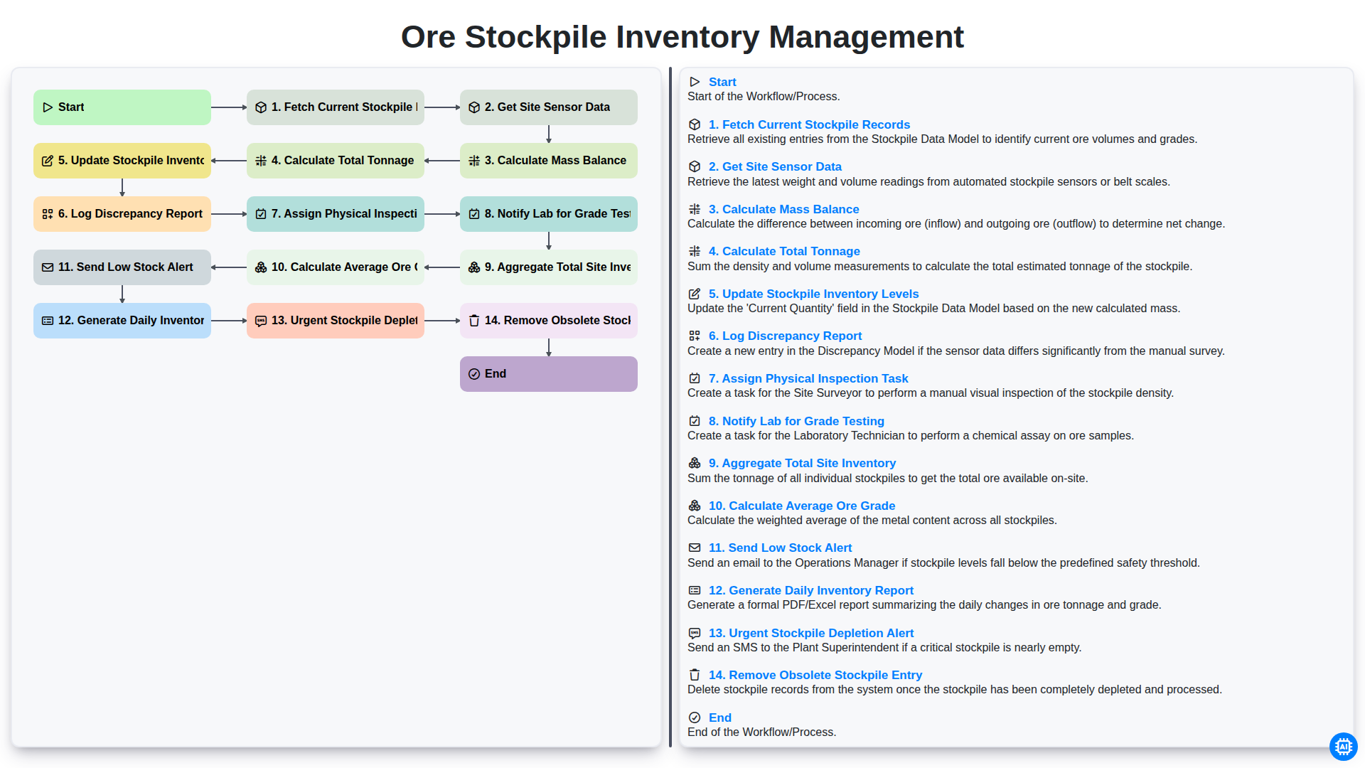
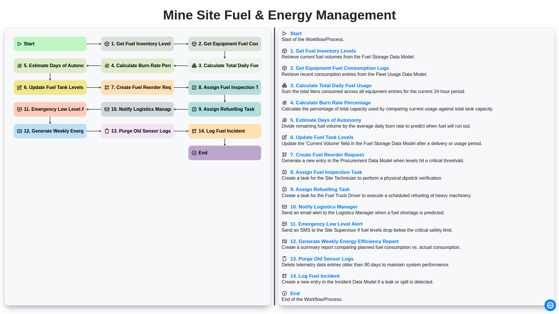
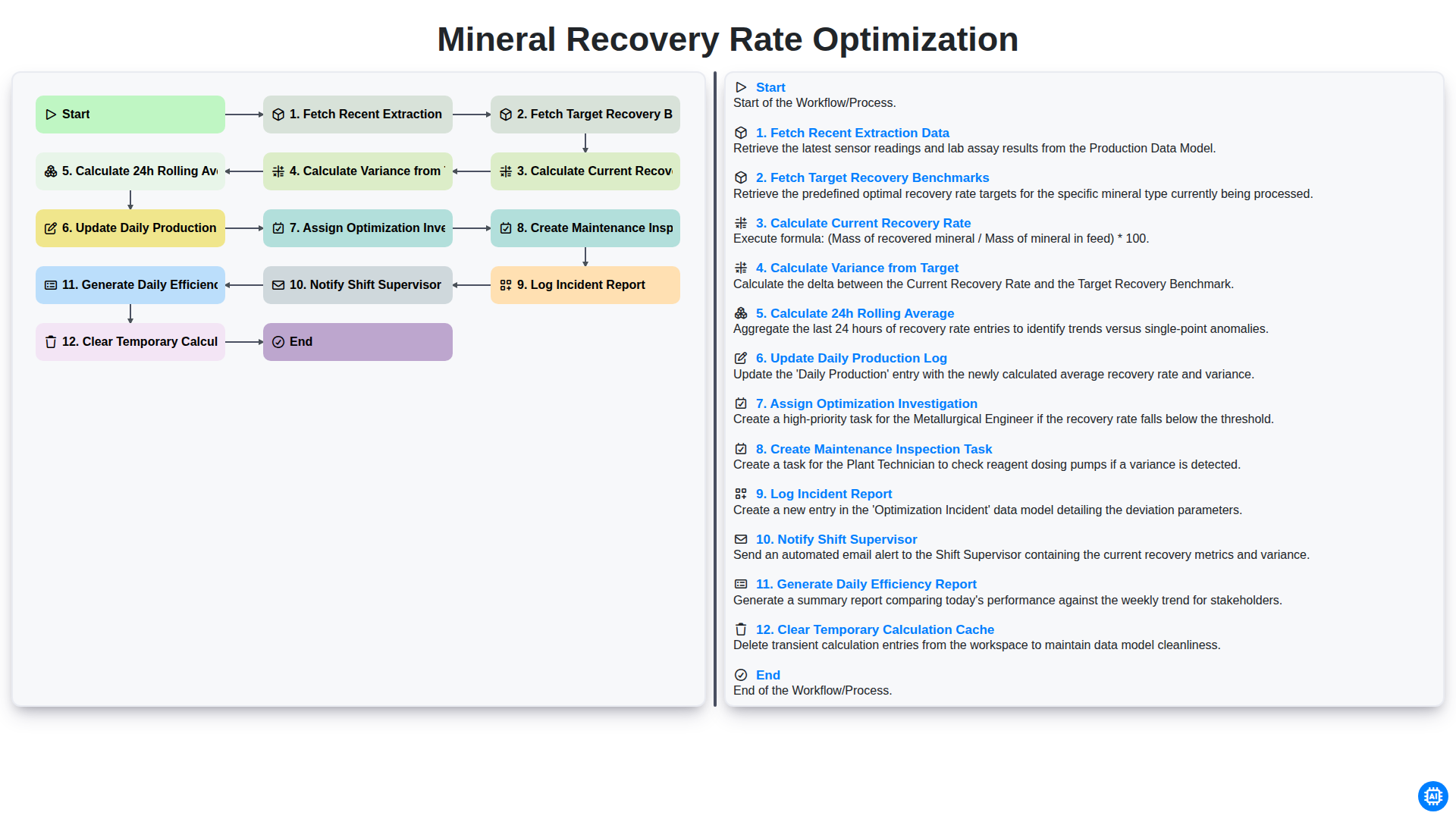
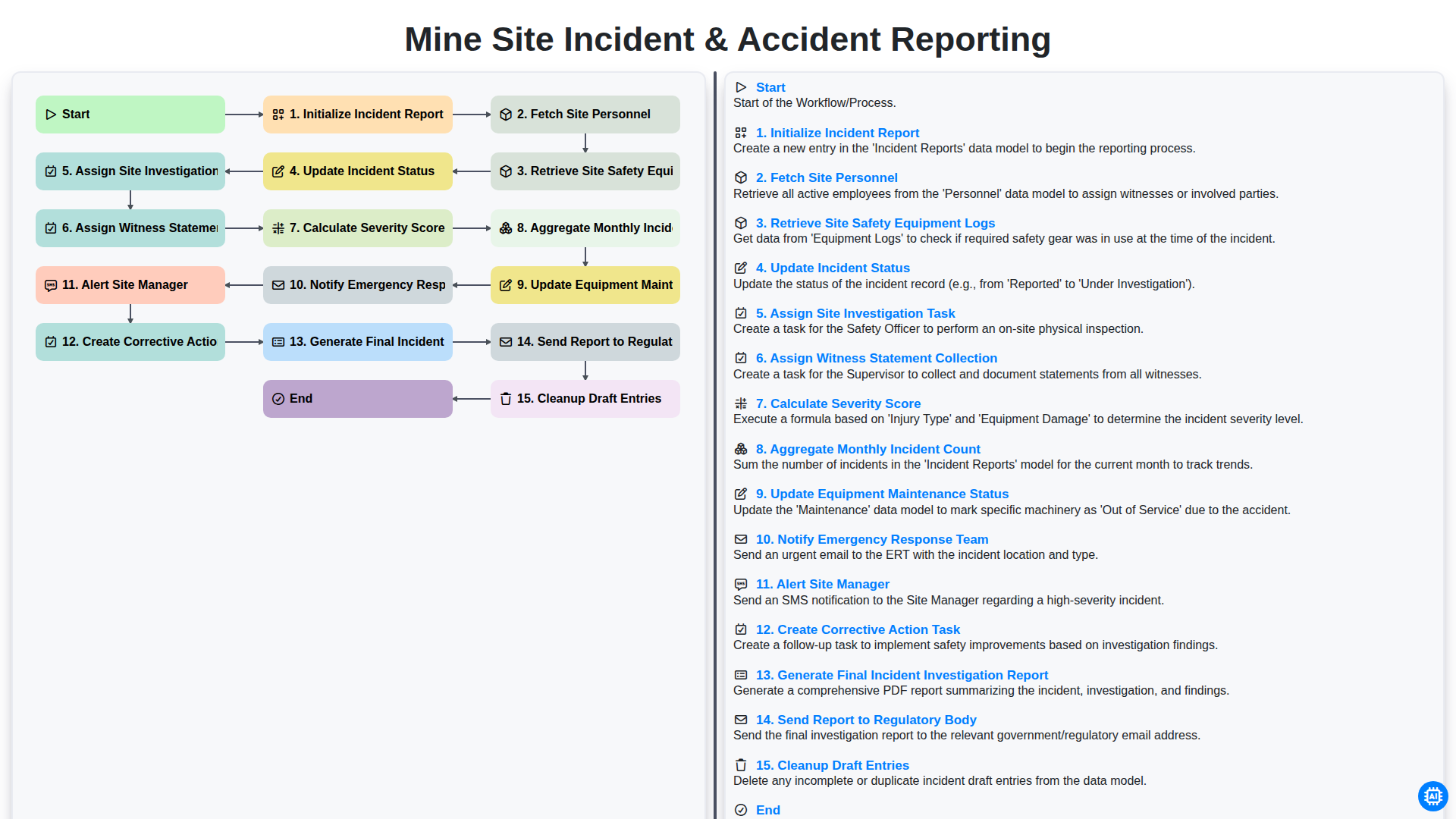
Start
Start of the Workflow/Process.
1. Retrieve Site Locations
Fetch all existing geological field sites and their metadata from the Site Location data model.
2. Assign Field Geologist
Create a task for a qualified geologist to perform the physical field mapping at the selected site.
3. Checklist: Field Sampling Protocol
Create a task containing a mandatory checklist for soil, rock, and mineral sample collection.
4. Create Field Observation Log
Generate a new entry in the Observation Log model to record real-time data captured during the survey.
5. Update Site Status
Update the selected Site Location entry status to 'In Progress' or 'Fieldwork Completed'.
6. Fetch Laboratory Results
Retrieve recent chemical assay results from the Lab Analysis data model associated with the site samples.
7. Calculate Mineral Concentration Index
Execute a formula to calculate the concentration index based on detected mineral mass and total sample volume.
8. Aggregate Average Metal Grade
Calculate the average grade of precious metals across all sample entries collected at the current site.
9. Generate Integrated Map Layer
Create a new entry in the Geospatial Layers model containing the processed spatial data.
10. GIS Specialist Review
Create a task for the GIS Specialist to verify the accuracy of the integrated digital map.
11. Finalize Site Report
Update the Site Report entry with the final validated geological findings and statistical summaries.
12. Generate Geological Summary Report
Compile all task completions, aggregated data, and field observations into a formal PDF summary report.
13. Notify Stakeholders
Send an email to the Project Manager and Exploration Director with the completed report attached.
14. Cleanup Temporary Field Notes
Delete temporary/draft entries in the Field Notes model once they have been successfully integrated into the permanent data model.
End
End of the Workflow/Process.
Start of the Workflow/Process.
Fetch all existing geological field sites and their metadata from the Site Location data model.
Create a task for a qualified geologist to perform the physical field mapping at the selected site.
Create a task containing a mandatory checklist for soil, rock, and mineral sample collection.
Generate a new entry in the Observation Log model to record real-time data captured during the survey.
Update the selected Site Location entry status to 'In Progress' or 'Fieldwork Completed'.
Retrieve recent chemical assay results from the Lab Analysis data model associated with the site samples.
Execute a formula to calculate the concentration index based on detected mineral mass and total sample volume.
Calculate the average grade of precious metals across all sample entries collected at the current site.
Create a new entry in the Geospatial Layers model containing the processed spatial data.
Create a task for the GIS Specialist to verify the accuracy of the integrated digital map.
Update the Site Report entry with the final validated geological findings and statistical summaries.
Compile all task completions, aggregated data, and field observations into a formal PDF summary report.
Send an email to the Project Manager and Exploration Director with the completed report attached.
Delete temporary/draft entries in the Field Notes model once they have been successfully integrated into the permanent data model.
End of the Workflow/Process.
Found this Workflow Template helpful?
Mining Management Solution Demo
Maximize efficiency & safety in mining operations! ChecklistGuro streamlines task management, equipment tracking, and compliance reporting. Optimize workflows, reduce risk, & boost productivity. Manage it all with our Work OS.
Related Workflow Templates
We can do it Together
Need help with
Mining Management?
Have a question? We're here to help. Please submit your inquiry, and we'll respond promptly.